Comerford Reservoir, Connecticut River, New Hampshire: Paddling with Dams is Damned!
 Looks nice doesn't it!?
The Comerford Reservoir, on the Connecticut River, borders New Hampshire and Vermont, in the United States.
Plenty of water, a nice sandy beach, easy boat launch, grass with picnic tables, lots of free parking, not much development along this stretch of the river towards the Moore Reservoir, and mountain views.
But what did I leave out of this shot just off to my left of the beautiful public access to the water?
A major development. The big monster. The dam monster. The Frank D. Comerford Dam.
There are much bigger dams of course. But they are all monsters for "us". Those of "us" who want to use the water once in a while, and know, "When is it safe for "us"? When can "we" use the water that you control? Could you let us know when it's OK?"
 And guess what. I was paddling towards an even bigger dam, the massive 178 foot high Moore Dam on the Moore Reservoir.
"During boating season, water levels could vary from up to nine or ten feet."
Hey wait a minute! Isn't that when "we' want to use the water?
Isn't nine or ten feet a pretty significant change in water levels?
I'm only here from Canada visiting for one week with my 17 foot sea kayak. How much research do I need to do if I want to paddle this river, or any river? Where can I find the information I need to know about dam locations and flow rates? The uber friendly tourist centres around here provide me with maps of the area and tell me where the launch sites are, and some of them are very near the dams, danger signs, and very much in between dams.
"TransCanada hydro Northeast provides many day-use public access ramps and picnic areas around the reservoirs."
Gee thanks! Aren't you nice! And all this, at my own risk, according to your DANGER signs. Such a deal.
Paddling with dams is damned!
You can Google land find flowcast information from a"
Ummm, really. What you are telling me (us) is that I can never go into "your water." How did you take it away from us so easily and in so many places?
No matter how much information is provided to the public, it's still hit or miss for us when dams are nearby.
On rivers we have to learn where and when it might be safe to paddle in between dams. I find it a lot of work and worry to research. Do you? And it keeps me off of some stretches of water I'd like to paddle more often.
On lazy summer or beautiful fall days, I never know what to think when I launch from public places they've created "for us" near one of their dams, and some of them can control a pretty wide berth of water and land. And there you are standing underneath one of their giant DANGER signs, far from the dam or right next to it. The ones that warn you that the water levels can suddenly change without warning. What kind of message does this send to the public, boaters, and paddlers?
For example, when you arrive at the "launch by the dam on the Comerford Reservoir", people are sitting on the picnic table. Families with children and dogs are swimming in the water right next to the dam with the big Danger sign next to their picnic table on the little sandy beach.
This bothers me!
How do we know when we can paddle or swim on our rivers? It seems that dams are controlling most or all of them. They are a necessary evil, and they are here to stay. So we need to know more about them. Where are they located? What kinds of flows are coming out of them at any time of year.
And, it's not easy to find out.
Is it really fair and reasonable to us, the public, boaters and paddlers, that water flows can change suddenly without warning because of them?
"If something happens to you, It's not our fault. We put up warning signs in some spots. On other parts of the river affected by what we do, well, that's your problem. Good luck! And, just try to contact some of us to find out about daily flows, predictions, or recommendations for the paddle you planned on "our river" and again, good luck! On most days, you'll be OK, except spring, other times of the year like summer and fall when you really want to paddle, you just never know. Maybe try cycling instead! We own the river now. Why don't you just boat or kayak on a lake or the ocean?"
That was my mock conversation with dam owners and operators, that I can't get a hold of or talk to when I want to plan a paddle on a river with a dam. Can you?
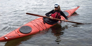
Looks pretty, doesn't it? The Comerford Reservoir. Yes.
 And it was a nice calm paddle the day I visited the Comerford Reservoir with no problems at all on a beautiful September day, despite the warning sign at the dam launch. And because of the dams, there was a lot of water for me to paddle on.
What's next for the BaffinPaddler?
The BaffinPaddler is researching dams in Canada and the United States.
It hit me at the Comerford Reservoir on the Connecticut River in New Hampshire, launching from the sandy beach and park with picnic tables and a parking lot for the public, next to the dam and a giant danger sign.
I've been thinking and wondering about dams for awhile as a paddler. I need to learn more.
I think we need better resources on the Web for the public and paddlers with information about dams that are useful to us when we want to plan a paddle or visit the water controlled by dams. Dams are a pain, and we're stuck with them! Researching a paddle is so much work!
A few paddlers have told me about hitting some scary or difficult water in between dams on rivers that would normally be quiet on lazy fall or summer days and they stopped paddling certain parts of rivers they liked.
We need a reliable Web resource about dams for paddlers with links to information that will make our paddle planning easier.
Happy and safe paddling.
The Baffin Paddler


There are "dams" and then there are "dams?" I've paddled near small dams like Island Creek http://www.durhamblogger.com/2010/10/wonderful-morning-paddling-at-kerr-lake.html and Holt Dam http://www.durhamblogger.com/2009/10/autumn-splendor-part-one.html There were warning signs posted to keep boaters away from the water intake / discharge pipes and machinery... as there should be! But, you could still paddle near both structures - in fact it was the dams that made both Kerr Lake and Lake Holt possible! ;-) So I understand why dam operators would post danger signs and warn folks to paddle at their own risk near the "business ends" of the dams. But I do agree with you that there should be better coordination and cooperation? on how folks can best utilize these wonderful paddling areas.
ReplyDeleteJust thought i'd say hi to a fellow Baffin paddler. Love the boat, also yet to learn a roll. Hopefully there are some "in pool" teaching sessions available this winter. It would be nice to learn a roll over the winter in time for some early spring paddling. Do you think the raised end of the baffin make it harder to roll?
ReplyDeletecheers
ian.
Great! Another Baffin Paddler. The Baffin is a great rolling boat. Anyone who can already roll says so. I own two great boats, and both are great rollers, the Maelstrom Vital, and the Boreal Baffin. It's just me. I need to keep working at it. Some people get it faster than others. And honestly, I've seen people I thought would never get it, they kept trying, and suddenly they got it. I'll keep trying too. The Maelstrom Vital fits me better, so I'll learn with it first.
ReplyDeleteLet us know when you get your first roll! I'd like to know what it feels like. It must be a great feeling. We need to encourage each other.
I think you pose some valid questions, as well as a great resource for dam flows. I will be interested in seeing what your research discovers. I've always suspected that much of the signage refers to emergency conditions, sudden downpours or a collapsing dam upstream, that much of the time they try to be consistent with releases. It would be nice to know what it really means.
ReplyDeleteI'm pretty sure that "cfs" stands for "cubic feet per second". I don't do a lot of paddling on bodies of water controlled by large dams so I have no useful experience to pass on. My feeling is that Mike is probably correct...areas close to dams can be dangerous places but the large bodies between them aren't going to suddenly jump up or down drastically - unless the dam fails! I do look forward to seeing what you learn on this topic though. One final thought - in Maine where I live, they've made pretty good progress removing old dams from our major rivers to help improve the fish spawning habitat. So dams aren't necessarily "forever" :)
ReplyDeleteThat's good news!
ReplyDeleteSo, how much progress have you made on investigating dams and securing someone to interview? Your post sparked my interest and I was able to locate a "few" resources that gave dam locations in NC, but not much else. As a side bar to a "pre-dam" story, you might find a recent post on my blog to be of interest: http://www.durhamblogger.com/2010/11/before-kerr-lake-interesting-history.html Let me know if you would like me to provide you with some links for your proposed Web resource on dams!
ReplyDelete